Wake up daily to our latest coverage of business done better, directly in your inbox.
Get your weekly dose of analysis on rising corporate activism.
The best of solutions journalism in the sustainability space, published monthly.
Select Newsletter
By signing up you agree to our privacy policy. You can opt out anytime.

Is It Time for the New York City Region to Plan for Permanent Flooding?
The greater New York City area is home to over 20 million people, or about 1 out of 16 U.S. citizens. And considering the economic opportunities and way of life this area that stretches as far as Connecticut to even Pennsylvania offers, the greater New York metro can only expect more future growth.
But climate change risks, especially sea-level rise, leave the Big Apple and its surrounding communities vulnerable in the coming decades. A recent study issued by the Regional Plan Association (RPA), which advocates for improved economic health and environmental sustainability in the wider metropolitan area, suggests that local leaders and urban planners need to do far more to mitigate the threats of sea-level rise than what is now under development.
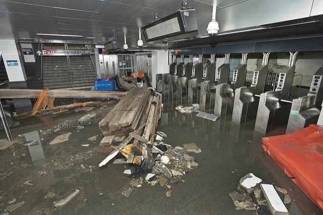
Four years after Hurricane Sandy left billions of dollars in damages, the region has already been far more proactive than other metropolitan areas at risk of flooding due to climate change. But between an aging infrastructure, natural subsidence and, of course, rising seas, much of the area will be lost -- leaving a huge impact on citizens and the region’s economy.
The RPA’s report assessed the risks the region could experience in scenarios that include levels of one, three and six feet of sea-level rise.
At one foot of sea-level rise, larger cracks start to appear in New York City’s infrastructure, according to RTA's projections. Areas such as Staten Island’s eastern shore, Jamaica Bay and Flushing Bay will suffer the most impact from regular flooding. The region’s transportation will deal with constant nuisances, such as LaGuardia Airport experiencing periodic closings due to intermittent flooding. High-density coastal communities in New Jersey tend to have better infrastructure and may be unscathed, but a few low-lying towns and the Teterboro Airport could begin to endure regular flooding.
Under a three-foot scenario, the region’s landscape begins to see more dramatic change. Connecticut communities such as Stamford, Bridgeport and New Haven start to lose shoreline real estate. The bustling Hoboken rail terminal will flood often, and many freight lines and distribution centers in the Meadowlands area will be lost -- which would be a significant blow to the regional economy. As many as 40,000 Long Island residents could see their homes uninhabitable. One of LaGuardia’s runways will be unusable; subways to coastal neighborhoods such as Howard Beach and the Rockaways will most likely be knocked out.
Naturally, at a sea-level rise of six feet, New York City’s landscape would witness a dramatic change. The city’s infrastructure, as it now stands, will not be resilient enough to prevent 200,000 New Yorkers from losing their homes. Industrial areas such as the Brooklyn Navy Yard and Sunset Park will be inundated. And JFK Airport, while not completely damaged to the degree as what would occur at LaGuardia, would have no choice but to close in the event of storm surges. Meanwhile, 165,000 Long Island residents would find themselves displaced, the Hudson River would take over areas long lost to land reclamation, and many of the iconic Jersey Shore resort communities that fuel the state’s tourism economy would disappear.
This dystopian future, however, could be avoided – and smart planning could also reduce the multibillion-dollar losses insurance companies would suffer under these scenarios.
The first priority, say the RPA authors, is to implement the climate commitments made last year in Paris. Planning for the worst scenarios, even those that will not happen until most of us are gone, needs to start now – or, in reality, yesterday. Decisions such as zoning updates, open-space protection plans and projects that could stem the threat of sea-level rise must be a leading conversation among local leaders and city planners now.
More data modeling, which could help insurance companies pinpoint the greatest risks, would also help.
Of course, all this planning would require generous funding for both short- and long-term risks. And in a nod acknowledging that those who live near the shoreline are not just the wealthy, the RPA’s researchers insist the poorest and most vulnerable are also accounted for, as they will have fewer work and economic options in what will most likely become a more volatile world.
Image credit: MTA/Flickr
Leon Kaye has written for 3p since 2010 and become executive editor in 2018. His previous work includes writing for the Guardian as well as other online and print publications. In addition, he's worked in sales executive roles within technology and financial research companies, as well as for a public relations firm, for which he consulted with one of the globe’s leading sustainability initiatives. Currently living in Central California, he’s traveled to 70-plus countries and has lived and worked in South Korea, the United Arab Emirates and Uruguay.
Leon’s an alum of Fresno State, the University of Maryland, Baltimore County and the University of Southern California's Marshall Business School. He enjoys traveling abroad as well as exploring California’s Central Coast and the Sierra Nevadas.