Wake up daily to our latest coverage of business done better, directly in your inbox.
Get your weekly dose of analysis on rising corporate activism.
The best of solutions journalism in the sustainability space, published monthly.
Select Newsletter
By signing up you agree to our privacy policy. You can opt out anytime.

Greenpeace Does What Government Hasn't: Releases Map of Indonesia Forest Concessions
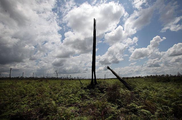
One of the biggest challenges when trying to determine who was responsible for last year's devastating fires in Indonesia was the lack of reliable information on concessions – namely, who, or what entity, was responsible for the land that burned. Greenpeace has done its best to fill this gap with a just-released land use map that is, by far, the best of its kind.
The map was no easy effort, with Greenpeace Indonesia staff digitizing paper maps and PDF files that they collected from numerous companies. They also made the data easy to use -- using the World Resources Institutes's open-source Global Forest Watch tool to turn it into a user-friendly website entitled Kepo Hutan, or “Curious about Forests.”
“Kepo Hutan allows the public to see the most detailed-ever company information, showing the borders of concessions and who owns them, and how it relates to peatlands, fire hotspots and deforestation alerts,” said Teguh Surya, Greenpeace Indonesia forest campaigner, in a statement.
Greenpeace released this map not as an end-all solution, but to spur the Indonesian government to move forward with its efforts to release a similar map, which, due to numerous factors, have stalled. This goes back to the decentralization plan pushed forward after the fall of General Suhato in 1998 (just a year after the last round of massive, El Nino-triggered fires), when Indonesia devolved significant natural-resources governance to the district and provincial level. What resulted was different ministries having different concessions maps at different levels, making the One Map initiative launched by previous President Susilo Bambang Yudhoyono now a multi-year, long-overdue process will a final date still yet-to-be determined.
“The transparency promised by President Joko Widodo, which includes the One Map agenda, is still an urgent and unmet need,” Surya said. “Greenpeace is making this map data available today both to spur progress on the stalled One Map, and to allow the public to prevent another crisis by monitoring fires in forests and peatlands.”
Kepo Hutan will allow us to better understand where fires burned last year, and also to monitor the next wave of fires that is already beginning across the region. The disaster – in which 2 million hectares burned – has resulted in some small-scale changes in Indonesia, but little accountability among the many corporations along the palm oil supply chain, such as PepsiCo, which, to this day, refuses to trace its palm oil openly and transparently.
With better information, and more tools like Kepo Hutan, we can better understand how fires connect to global supply chains. Let's hope the Indonesian government releases its One Map soon, so that we can begin the long process toward ensuring that, in the near future, no more fires burn through Indonesia's tropical heritage.
Image credit: Wikimedia Commons
Nithin Coca is a freelance journalist who focuses on environmental, social, and economic issues around the world, with specific expertise in Southeast Asia.


.jpg)